Precision Agriculture, Powered by Drone Intelligence
From crop disease diagnostics and insect detection to soil health mapping and wildlife monitoring — our hardware and AI bring field intelligence to the farmer.
Crop Health & Disease Diagnostics
Detect disease pressure before it becomes economic loss. Our AI vision algorithms analyse drone footage in real time, flagging areas of stress, discolouration, fungal infection and pathogen spread — enabling targeted intervention instead of blanket treatment.
- Early-stage detection of fungal diseases such as late blight, powdery mildew, and septoria leaf blotch
- Nutrient deficiency mapping — nitrogen, iron and magnesium stress visible from the air
- Automated zone generation for variable-rate application (VRA) prescription maps
- Offline-capable processing via Brain-Box: no internet required in the field
- Geofenced autonomous missions ensure repeatable, survey-grade coverage

Insect Detection & Pest Monitoring
Globally, insect pests account for an estimated 20–40% of annual crop losses. Aerial AI monitoring gives early warning of infestations that are invisible from the ground — so you spray less, save more, and protect your yield.
- Fly targeted grids over suspect areas to identify pest hot spots before spread
- Time-stamped geolocated event logs for agronomic record-keeping
- Compatible with thermal imaging for nocturnal activity monitoring
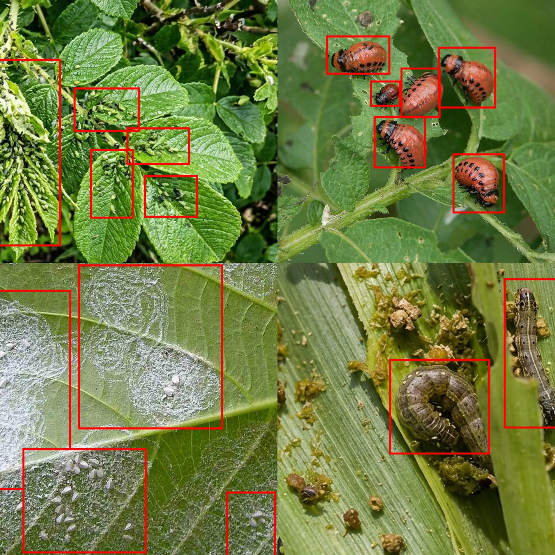
Aphids
Among the most damaging crop pests worldwide, aphids drain plant sap, transmit over 100 plant viruses, and can double their population every 24 hours under warm conditions. Colonies on cereal, brassica, and vegetable crops can crash yields by up to 40%.
Fall Armyworm
Since arriving in Africa in 2016, fall armyworm has devastated maize crops across 44 countries. A single adult moth can travel 100 km per night, laying hundreds of eggs. Early aerial detection is critical to contain spread before larvae reach destructive instars.
Whitefly
A major vector of over 300 plant viruses including tomato yellow leaf curl, whitefly colonies create visible yellowing and sticky honeydew residue. Particularly devastating in protected horticulture and subtropical vegetable production.
Locusts
Desert locust swarms consume the equivalent of 35,000 people's daily food in a single day. Drone-based aerial detection enables early swarm identification and deployment guidance for intervention teams, critical across East Africa and the Middle East.
Colorado Potato Beetle
A notorious defoliator of potato and tomato crops, the Colorado potato beetle has developed resistance to over 50 pesticide compounds. Mapping colony boundaries from the air supports precision intervention and resistance management.
Diamondback Moth
The world's most costly insect pest of brassica crops, causing estimated annual losses exceeding €4 billion. Monitoring crop canopy health via aerial imaging identifies early feeding damage on cabbage, broccoli, and canola.
Spider Mites
Two-spotted spider mites thrive during drought stress and cause characteristic bronzing and stippling visible under aerial imaging. They are particularly damaging in corn, soybean, and fruit orchards during hot, dry summers.
Thrips
Western flower thrips transmit the devastating tomato spotted wilt virus. Their small size makes ground scouting tedious and inaccurate; AI-assisted drone imaging of canopy symptoms dramatically reduces scouting time and improves outbreak response.
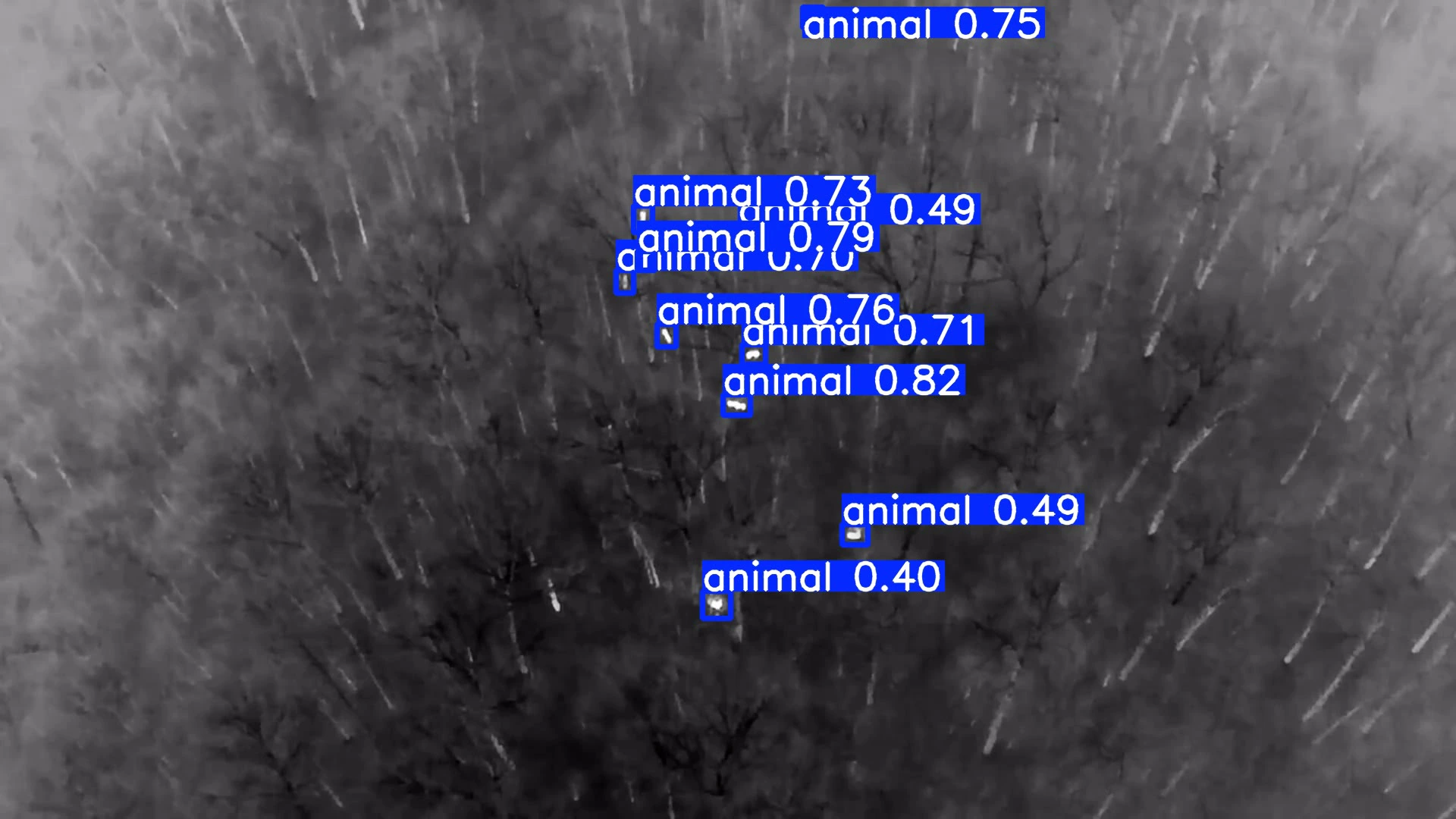
Wildlife & Livestock Detection
Our AI algorithms detect and classify large animals in real time — from both RGB and thermal sensors. Whether you're protecting your herd, managing wildlife corridors, or monitoring for predator intrusion, our system delivers reliable identification day and night.
- Livestock welfare checks — rapidly survey large pastures for injured or isolated animals, reducing ground patrol time by hours
- Wolf & predator monitoring — detect wolf presence near grazing land at dawn and dusk when ground visibility is low; thermal algorithms work in total darkness
- Wild boar intrusion alerts — boar cause millions in crop damage annually across Europe; early detection enables timely deterrence before herds root up fields
- Deer population mapping — support deer management programmes, crop damage assessments, and fence integrity planning
- Thermal + RGB fusion — dual-sensor detection dramatically reduces false negatives in dense vegetation or woodland-edge habitats
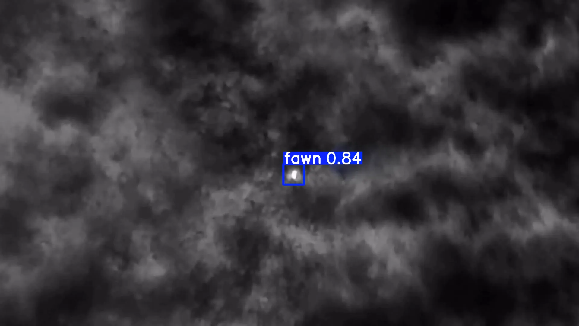
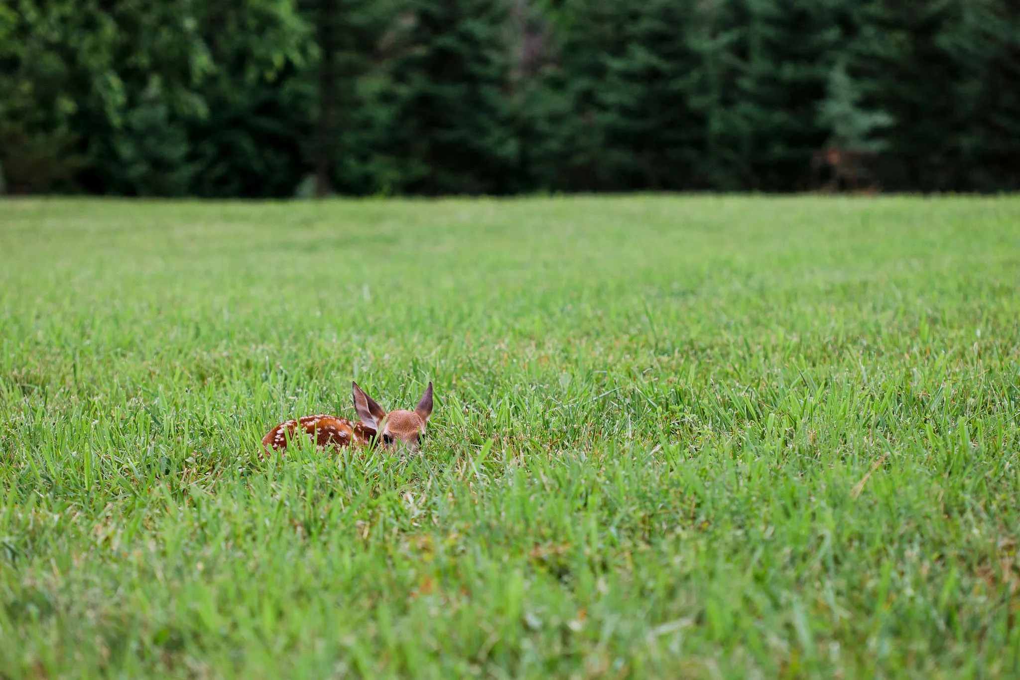
Fawn Detection — Protecting Life Before the Mow
Every year, thousands of fawns are killed by agricultural machinery during the spring and early summer mowing season. Roe deer does instinctively hide their young in tall grass — exactly where mower blades pass. It's one of the leading causes of preventable wildlife death in European agriculture, and it happens in minutes.
- Dedicated thermal AI model trained specifically to detect the heat signature of a curled fawn at rest — distinguishing it from warm soil patches, rocks, and small debris
- Optimised flight altitude of 40 m to maximise thermal contrast while minimising acoustic disturbance to surrounding wildlife
- Pre-mow survey workflow: fly the field, review flagged GPS coordinates, remove or mark fawns before machinery enters
- Works in first light and low-visibility conditions when mowing typically begins
- Rapid deployment — a 10-hectare field can be surveyed in under 15 minutes
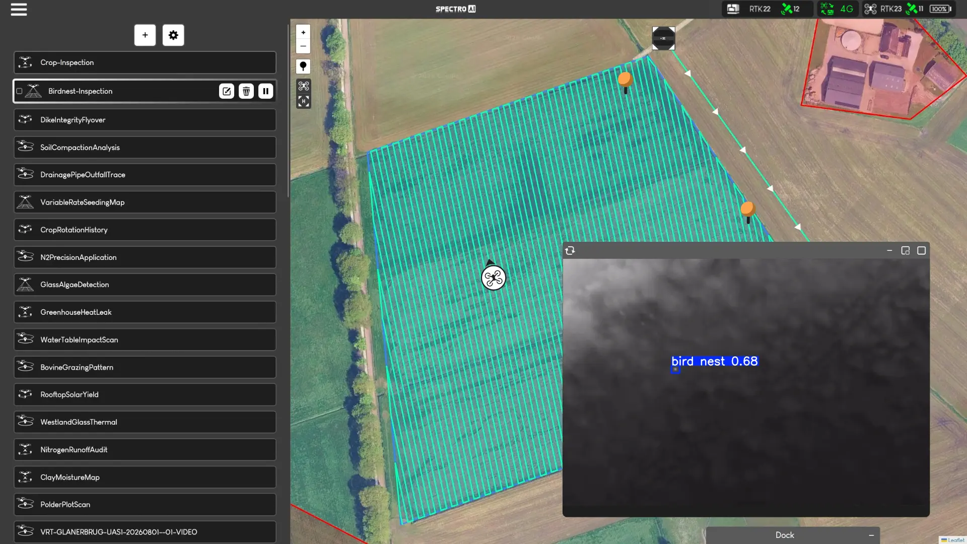
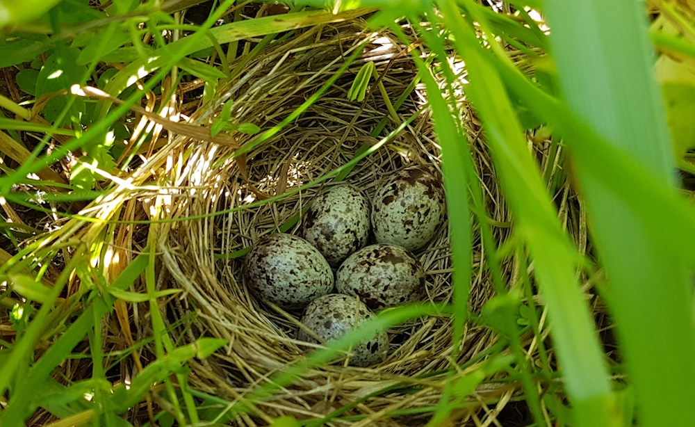
Bird Nest Detection & Ground-Nester Protection
Agricultural intensification has driven catastrophic declines in ground-nesting farmland birds. Many of Europe's most threatened species lay directly in crop fields, meadows, and grassland — making them acutely vulnerable to cultivation, mowing, and spraying operations. Our AI nest detection algorithm enables farmers and land managers to survey fields before operations begin, protecting nests in minutes rather than hours of foot survey.
- AI identifies nest structures, eggs, and brooding adults in high-resolution drone imagery
- GPS-tagged nest coordinates exported for machinery avoidance zones or manual protection
- Survey results support agri-environment scheme (AES) compliance and ecological impact assessments
- Ideal for conservation NGOs, estate managers, and arable farmers in stewardship programmes
Species Our AI Algorithms Could Help Detect
Northern Lapwing
Once a ubiquitous farmland bird, lapwing populations have declined by over 60% since 1980. They nest directly on bare soil in arable fields, making spring tillage a major threat. Drone surveys before first cultivation are critical.
Eurasian Curlew
The curlew is Europe's most urgent bird conservation priority. Upland populations have collapsed; lowland nesting pairs remaining in improved grassland face severe mowing mortality. Each nest found and protected matters.
Skylark
Skylarks nest in shallow scrapes in cereal fields. Modern drilling patterns and early cutting have eliminated traditional nesting refuges. AI nest detection in winter cereal crops can identify active skylark plots for untreated patches.
Corn Crake
Corn crakes nest in hay meadows and are among the most secretive farmland birds in Europe. Their population decline has been directly linked to early mechanical mowing. RSPB and BirdLife programmes prioritise nest detection in active hay fields.
Montagu's Harrier
A migratory raptor that nests in cereal crops across France, Spain, and Germany, Montagu's harrier nests are frequently destroyed by combine harvesters. Nest detection and GPS marking before harvest is now a legal obligation in some regions.
Stone Curlew
Stone curlews nest on bare arable ground and can be overlooked during field operations due to their cryptic colouring. Drone-based imagery combined with AI classification reliably detects incubating adults invisible to the naked eye from field margins.
Black-tailed Godwit
The Netherlands holds over 80% of the global islandica race. Nesting in wet meadows, godwit clutches are routinely destroyed by drainage equipment and early mowing. This is a primary use case for drone nest detection in Dutch agricultural landscapes.
Little Bustard
Little bustards nest in open steppe and semi-arid farmland across Iberia and France. Large home ranges and low nest density make ground surveys inefficient — drone AI surveys cover dozens of hectares per flight, dramatically improving detection rates.
Soil & Water Health Mapping
The HyperSlit is a fully integrated hyperspectral imaging system designed to make collecting precise environmental data as simple as flying a drone. Where traditional soil sampling requires days of manual coring and laboratory analysis, HyperSlit produces interpolated, georeferenced spectral maps in a single flight — giving researchers and agronomists field-wide insight that simply wasn't possible before.
Why HyperSlit Changes the Way You Collect Data
Traditional spectroscopy requires skilled operators, ground-based equipment, and dozens of manual sample points. HyperSlit removes every one of those bottlenecks. Mount it to your drone, fly your pre-planned mission, and the system handles spectral capture, GPS tagging, irradiance correction, and map generation automatically. The result is a calibrated, analysis-ready GeoTIFF — exportable into any GIS or research platform.
- Integrated irradiance spectrometer (180° FoV) corrects for changing light conditions mid-flight — no manual recalibration required
- Co-axial RGB camera captures visual context alongside spectral data in a single pass
- On-board RTK GNSS module ensures sub-decimetre geolocation accuracy for every spectral sample
- Outputs interpolated .GeoTIFF maps compatible with QGIS, ArcGIS, and all major agronomy platforms
- 128 GB onboard storage — data efficient and air-gapped; no cloud dependency required
- Android live data application for real-time spectral preview during flight
- Desktop post-processing application included — researchers get from raw capture to mapped output in under an hour

Water Research Parameters
- Chlorophyll-a — algae and cyanobacteria concentration in surface water bodies
- Total Suspended Solids (TSS) — turbidity and sediment load mapping in rivers and ditches
- Colored Dissolved Organic Matter (CDOM) — carbon content and water colour analysis
- Nitrate (NO₃⁻) — fertiliser runoff detection and eutrophication risk assessment
Soil Research Parameters
- Iron and Aluminium Oxides — redox status, drainage class, and parent material mapping
- Moisture Content — field-wide moisture variability for irrigation scheduling
- Soil Texture — clay/silt/sand distribution from spectral response curves
- Nutrient Levels — potassium, phosphorus, and nitrogen proxies for variable-rate fertilisation
More Use Cases in Agriculture
Our hardware and AI platform opens the door to a range of high-value agricultural and environmental applications — many of which are rapidly becoming commercially viable as sensor resolution and AI accuracy improve.
Algae Detection in Greenhouse Glass
Algae growth on greenhouse panels reduces light transmission by up to 30%, directly suppressing crop growth. HyperSlit's UV/VNIR spectral sensitivity can map chlorophyll-based algae contamination across glass surfaces, enabling targeted cleaning programmes and reducing energy and labour waste.
Greenhouse Heat Leak Detection
Heating accounts for up to 70% of greenhouse operating costs. Thermal drone surveys identify structural heat loss through panels, seams, vents, and foundations with pinpoint precision — enabling rapid repair prioritisation and significant energy savings.
Clay Moisture Mapping
Soil moisture and clay content vary dramatically across a single field, affecting trafficability, compaction risk, and irrigation scheduling. HyperSlit's NIR wavelengths detect clay mineral absorption features — producing field-wide maps without a single soil core.
Yield Estimation & Harvest Planning
Combining vegetation indices from HyperSlit spectral data with AI canopy analysis from SAI-HUB gives farm managers pre-harvest yield predictions down to sub-field resolution — supporting contract planning, logistics, and input budgeting.
Dike & Embankment Integrity
Drone surveys detect subsidence, erosion, vegetation stress, and surface cracking faster than foot patrol. HyperSlit's moisture mapping adds a subsurface dimension, flagging water saturation before visible failure occurs across thousands of kilometres of flood defence.
NDVI & Vegetation Index Mapping
HyperSlit produces hundreds of spectral bands — enabling NDVI, NDRE, PSRI, mNDVI705, and custom indices calibrated to specific crop species and phenological stages. A research-grade spectral library buildable directly from field missions.
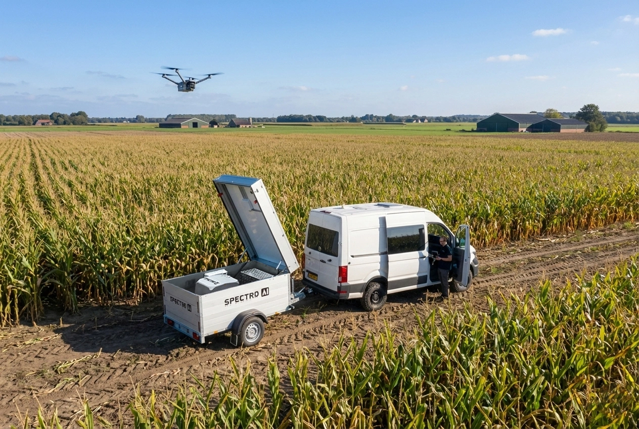
Operate Across Multiple Fields — Without Moving a Team
For farms where land is spread across multiple locations kilometres apart, deploying a drone team to every site is simply not viable. The DockWatch Trailer changes that. It's a fully autonomous drone docking and recharging station mounted on a towable trailer — deployable anywhere a vehicle can reach.
- Leave it, launch it — deploy the DockWatch Trailer at a remote field in the morning, return to other work, and review mission data that evening
- Scheduled missions — programme repeat surveys at precise times; ideal for daily crop monitoring without daily presence
- Multi-site rotation — tow the trailer between farm units; one system, multiple locations, zero compromise on coverage
- Long-range crop protection — combine with SAI-HUB to run automated pest and disease detection sweeps on isolated parcels where early visits are logistically difficult
- Wildlife activity monitoring — station the trailer overnight near high-risk areas (livestock fields adjacent to woodland) for automated predator and boar alerts
- Emergency response — detect flood ingress, fire, or infrastructure damage on outlying fields immediately, not after the next site visit
Fully Autonomous Detection — Powered by DJI Dock
The SAI-HUB DD (Dock Deployment) integrates directly with the DJI Dock for fully autonomous, unattended drone operations. No pilot required on site. Schedule missions, receive detections, and review results — remotely. Ideal for large farms, nature reserves, and precision agriculture operations that demand 24/7 coverage without daily staffing.
- Zero-presence operation — the drone launches, completes its AI mission, and returns to dock automatically, without any human on site
- Scheduled daily or triggered missions based on predefined conditions or time windows
- All 15+ AI detection algorithms available autonomously: crop health, pest, fawn, bird nest, wildlife, and more
- Remote mission monitoring via live map feed — review detection events from anywhere
- DJI Dock handles charging and weatherproofing — operational in rain, wind, and low-light conditions

Complete Field Intelligence — In Your Hands
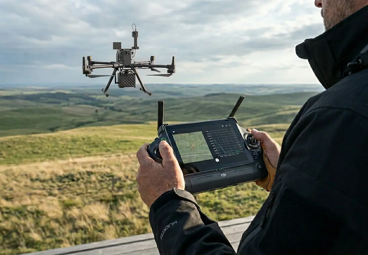
The SAI-HUB RC runs all AI detection directly on the drone controller — no dock, no laptop, no internet. It puts 15+ preloaded algorithms, autonomous mission planning, and offline-capable operation into a single rugged handheld device. Perfect for operators who need full flexibility in the field.
- All AI processing runs on the controller itself — detection results appear live on your screen during flight
- Draw or import no-fly zones and field boundaries directly on the controller display
- Upload custom offline maps stored locally on the Brain-Box — full resolution without connectivity
- Custom pre-flight checklist system ensures consistent, audit-ready mission preparation
- Intelligent Return-to-Home handles unexpected flight scenarios safely
- Live computer vision overlay — detection events annotated on the map feed in real time

Ready to Bring Drone Intelligence to Your Farm?
Whether you're a researcher, farm manager, conservation professional, or integrator — our team will find the right configuration for your operation.